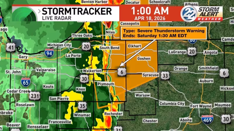
A tornado warning is in effect until 1:30 a.m. for parts of northern Indiana and southwest Michigan, while a severe thunderstorm warning covers additional counties on both sides of the state line. The alerts come as a large cold front moves through the area late Friday into Saturday.
The tornado warning covers Elkhart County, St. Joseph County, Marshall County and Kosciusko County in Indiana, along with southwestern Cass and southeastern Berrien County in Michigan. The severe thunderstorm warning includes St. Joseph, northwestern Fulton, eastern Pulaski, Starke, Marshall and LaPorte counties in Indiana, as well as Cass and Berrien counties in Michigan. A tornado watch remains in effect until 3 a.m. Saturday.


Most of the area is under a Slight risk for severe weather, a level 2 out of 5, while far eastern counties are under a Marginal risk, level 1 out of 5. The main threat is damaging wind, though an isolated tornado cannot be ruled out and isolated damaging hail is also possible.
The setup is a fast-moving weather system, not a long-lived outbreak, but that does not make it harmless. The cold front is strong enough to keep warnings active overnight, and the weather Indianapolis area will feel the shift quickly as storms move through before temperatures drop into the 40s and 50s on Saturday.
Rain chances during the day on Saturday are low, so once the storms pass, the bigger change will be the cooler air left behind. The immediate concern is getting through the overnight window safely, because the warning area is broad and the strongest weather can develop with little lead time.