NASA Science has published a look at Yunlin County in southwestern Taiwan, where Landsat imagery shows a tight agricultural patchwork of rice, sweet potatoes, peanuts, corn, sugarcane, garlic, scallions, coffee, fruit and leafy greens. The county also raises millions of pigs, making it one of Taiwan’s main agricultural hubs.
The scene matters because Taiwan has about 23 million people on an island about the size of Maryland, yet only about one-quarter of its land is arable. Even so, the country produces about $18 billion in agricultural goods each year, and the farms that support that output are often small enough to seem almost stitched together by roadways and irrigation canals.
In Yunlin, those plots are usually rectangular and compact. The average farm in Taiwan is less than 1 hectare, compared with 87 hectares in the United Kingdom and 187 hectares in the United States. Taiwan has just 0.03 hectares of farmland per citizen, so every square meter of workable ground carries more weight than it would in larger farming economies.
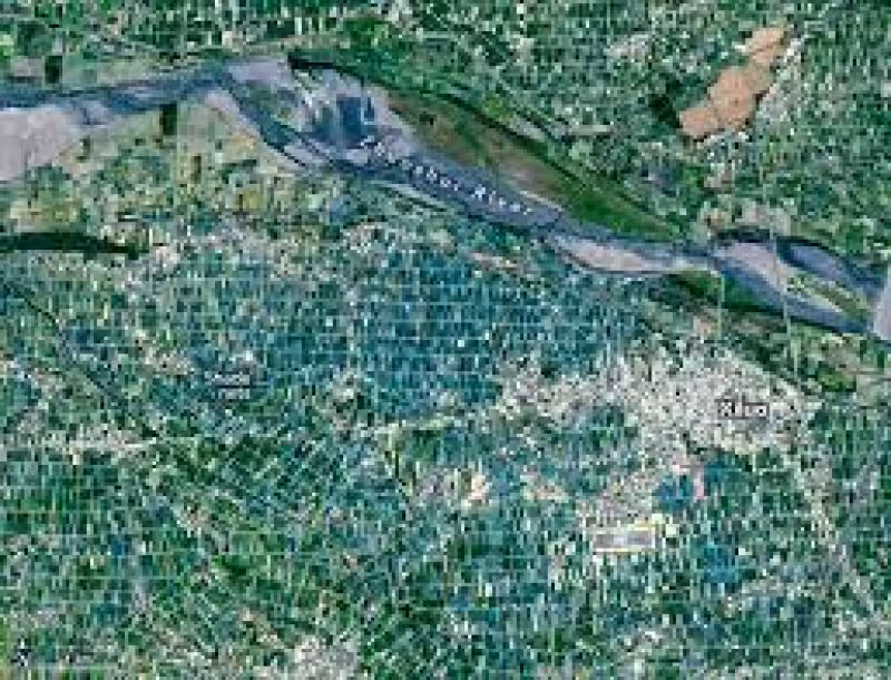
Most of Taiwan’s arable land sits on the southwestern side of the island in the Chianan Plain, and Yunlin County is one of the region’s most productive agricultural areas. It lies along the floodplains of the Zhoushui and Beigang rivers, where flat terrain, fertile soils and easy access to irrigation water have long supported intensive farming. The darker green area in the lower right of the first image is dominated by rice.
The county’s layout also reflects its history. Sugarcane was grown widely there in the early 1900s when Japan controlled Taiwan, and Japan established an expansive network of sugarcane plantations across southwestern Taiwan. After World War II, those plantations were consolidated into the Taiwan Sugar Corporation, and the legacy remains visible today in larger plots north of Baozhong, where the company still raises sugarcane.
That old system has mostly faded. The amount of sugarcane cultivated in Taiwan has declined in recent decades, and many former cane fields have shifted to other crops. Still, the Taiwan Sugar Corporation operates a railway that carries harvested cane to Huwei, where one of just a few remaining sugar refineries on the island stands. The line serving Huwei is the only active sugar railway line left in Taiwan.
Another feature of the county stands out in the imagery around Xiluo: a greenish-blue cast caused by widespread shade nets. Farmers use the nets to protect crops from heat, sun, heavy rains and pests, especially for vegetables, fruit and flowers. On the ground, the result is a landscape that looks orderly from above but is shaped by a long mix of history, water, policy and family inheritance. The small size of many farms reflects both limits once placed on farm size and the way land has been divided among heirs over generations.
For Taiwan, the message in the image is plain. In a mountainous country with little arable land, agriculture survives not through scale but through density, adaptation and a landscape built to squeeze as much as possible from every available hectare.