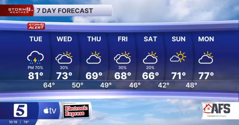
Heavy rain and strong storms will exit tonight, but not before parts of the region face another round of rough weather. A Severe Thunderstorm Watch remains in effect until 4 AM Tuesday morning, and a Flood Watch stays up until 2 AM Tuesday as storms with heavy rain move south after midnight.
Storms during the evening could produce damaging wind, isolated tornadoes, and flooding, with total rainfall ranging from 1/2 inch to over 2 inches. Lows will settle in the 50s. More rain is possible Tuesday night and Wednesday morning, with areas of morning rain on Wednesday and mostly cloudy skies. Highs Wednesday are expected in the mid to low 60s, and lows Wednesday night could fall into the low 40s and upper 30s.
The bigger change comes later in the week, when below average temperatures are on track for the end of the work week and the coming weekend. Highs are expected to hold in the 60s and 50s, with overnight lows in the 40s and 30s, and some new record could occur during the cooler stretch. For now, the break in the pattern should help Saturday morning’s Indy Mini Marathon and 5k, when conditions are expected to be pretty good.
The forecast still leaves one short-term wrinkle: some rain could build in from the south during the evening, and cloudy skies with areas of rain remain possible before the system fully clears. After that, the next headline is not more severe weather but a sharp turn toward a much cooler week, the kind that can reset the whole rhythm of the forecast in a matter of days.