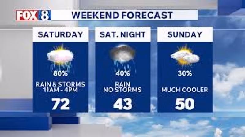
A 19 First Alert Weather Day is in place for Saturday as a strong cold front sweeps through the area, bringing gusty winds and thunderstorms. The storms are expected to track south and east of Cleveland, with Akron, Youngstown and Canton among the communities most likely to be hit between noon and 4 p.m.
That window matters because the system is expected to move fast but hit hard enough to change the feel of the day in a matter of hours. After it passes, temperatures are expected to fall into the upper 40s and lower 50s overnight, and those numbers are likely to become Sunday’s highs.
The shift does not stop there. Cooler air is expected to arrive from the north and west on Sunday, and lake effect showers are likely by Sunday evening. As the sun sets, some of those showers may mix with snow overnight, with the snowbelt possibly seeing the activity linger through the early morning hours of Monday’s commute. Accumulations are not likely.


By Monday afternoon, drier air is expected to move in and sunshine should return, though temperatures are forecast to hold in the upper 30s and lower 40s. The cool stretch should not last long. Highs are expected to return into the 60s by Tuesday, then a weak front may bring a few shower chances overnight Tuesday night into Wednesday morning before 70s return to the area by the end of the week.
The day before the change was described as beautiful, a brief calm before a weather pattern that brings a cold front, much cooler air and then another warmup later in the week. For now, Saturday is the day to watch, and the most important part of the forecast is the timing: the strongest storms are expected during the middle of the day, not after dark.
That is what makes the weekend setup clear. The immediate threat is Saturday’s storm window, the bigger change comes with the sharp drop in temperatures Sunday, and the close is a quick return to milder weather by Tuesday and the 70s by week’s end.